- UNSW
- ...
- Centre for Ecosystem Science
- Our research
- Terrestrial ecosystems
- Does overgrazing reduce ecosystem functions
- Home
- About us
-
Our research
- Atmospheric
-
Conservation practice
- Water Information System for the Environment (WISE)
- Red list of ecosystems
- Shrub encroachment as a legacy of native mammal decline
- Foraging and habitat ecology of the yellow-tailed black-cockatoo
- Tackling prey naïveté in Australia’s threatened mammals
- Biodiversity sampling in Strzelecki Regional Reserve
- The reintroduction of locally extinct mammals: The landscape ecosystem approach
- The persistence of common wombats in road impacted environments
- Temperate highland peat swamps on sandstone
- Cumberland plain woodland restoration
- Strategic adaptive management
- Limit to climate change adaption in floodplain wetlands - Macquarie Marshes
- Managing for ecosystem change in the greater blue mountains world heritage area
- Adaptive management of Ramsar Wetlands
- Managing for biodiversity in boom and bust cycle environments
- Submission on Biodiversity Act Review
- Marine ecosystems
-
Remote sensing and GIS
- Mangrove response to climatic variability
- Using radar satellite imagery to detect and monitor flooding in arid Australian wetlands
- Supporting continental retrieval of vegetation biophysical attributes
- The Injune Landscape Collaborative Project
- Tree species shifts in response to environmental change
- Regrowth mapping
- Regional biodiversity responses to climate change
- Will climate change affect the ecology of temporary lakes in Australia?
-
Rivers and wetlands
- Changes to the Darling River and Menindee Lakes – past, present and future
- Lowbidgee wetlands of the Murray-Darling Basin - The Nimmie-Caira
- A stitch in time – synergistic impacts to platypus metapopulation extinction risk
- Tube fishway project
- National waterbird survey
- Eastern Australian waterbird survey
- Feather map of Australia
- Life history and dynamics of a platypus (Ornithorhynchus anatinus) population: four decades of mark-recapture surveys
- Adequacy of environmental assessment of the proposed Macquarie River pipeline to the city of Orange
- Increasing production from inland aquaculture in Papua New Guinea for food and income security
- Aquaculture and environmental planning group
- Understanding soil-related constraints on aquaculture production in the highlands of Papua New Guinea
- Improving technologies for inland aquaculture in Papua New Guinea (ACIAR Project FIS2014062)
- Drying of ancient Thirlmere Lakes caused by human activities
- Application of GIS and remote sensing to assess sustainable mariculture and protect conservation zones
- Improving the sustainability of rice-shrimp farming systems in the Mekong Delta, Vietnam
- A SWOT analysis of Papua New Guinea’s inland fisheries and aquaculture sectors
- Carbon and floodplain biota in the Macquarie marshes
- Micro-invertebrate community dynamics and flooding in the Macquarie marshes
- Just add water? The effectiveness of environmental flows during wetland vegetation restoration
- Application of motion sensing cameras as a tool for monitoring riparian fauna
- Captive or wild?
- Brolga and Sarus crane diet comparison
- Lake Brewster pelican banding
- Aquatic invertebrate strategies for coping with drought
- Submission on Draft Lake Eyre Basin Strategic Plan
- The Menindee Lakes Water Savings Project – an example of poor decision-making
- Flow-MER
-
Terrestrial ecosystems
- Post-fire recovery of threatened ecological communities
- Environment Recovery Project: Australian bushfires
- Community stability of upland swamp vegetation
- An innovative approach to maximising catchment water yield in a changing climate
- Post-fire seed production in Hakea Gibbosa
- Managing fire regimes with thresholds to save threatened flora and fauna
- Stopping the toad
- Trophic cascades in NSW North Coast forests
- Individual hunting behavior in feral cats
- Mallee Ecosystem Dynamics
- Investigating artificial waterhole utilisation and management in north-eastern Botswana
- Investigating the spatial ecology, habitat use, behaviour, and ecosystem engineering of hippopotamus (Hippopotamus amphibius), a keystone species in the Okavango Delta and Chobe River, northern Botswana
- Does overgrazing reduce ecosystem functions
-
Study with us
- Courses
-
Postgraduate research projects
- Platypus breeding
- Maximising establishment success in reintroduced populations
- PhD scholarship saving our species - patch value, viability and resilience
- PhD scholarship – mechanics of species irruptions
- Conservation ecology of Greater bilby: survival, reproductive success and movement ecology in a breeding sanctuary in NSW
- Scientia PhD scholarship - Identifying healthy burning practices for Australia’s threatened plant species
- Scientia PhD scholarship - Ecosystem restoration through rewilding
- Platypus population health and dynamics
- Tackling prey naiveté in Australia’s endangered mammals
- Testate amoebae: a new biomarker of climate change and human impact in peatlands
- Surface water dynamics as a function of climate and river flow data
- Multisensor integration for environmental flows
- Response of northern Australian mangroves to climatic variability
- Comparative effects of extreme heat on threatened desert mammals
- Alumni - Where are they now?
- FAQ
- Workshops
- Our Impact
- News
- Wild Deserts
- Flow-MER
- Home
- About us
-
Our research
Conservation practice
- Water Information System for the Environment (WISE)
- Red list of ecosystems
- Shrub encroachment as a legacy of native mammal decline
- Foraging and habitat ecology of the yellow-tailed black-cockatoo
- Tackling prey naïveté in Australia’s threatened mammals
- Biodiversity sampling in Strzelecki Regional Reserve
- The reintroduction of locally extinct mammals: The landscape ecosystem approach
- The persistence of common wombats in road impacted environments
- Temperate highland peat swamps on sandstone
- Cumberland plain woodland restoration
- Strategic adaptive management
- Limit to climate change adaption in floodplain wetlands - Macquarie Marshes
- Managing for ecosystem change in the greater blue mountains world heritage area
- Adaptive management of Ramsar Wetlands
- Managing for biodiversity in boom and bust cycle environments
- Submission on Biodiversity Act Review
Remote sensing and GIS
- Mangrove response to climatic variability
- Using radar satellite imagery to detect and monitor flooding in arid Australian wetlands
- Supporting continental retrieval of vegetation biophysical attributes
- The Injune Landscape Collaborative Project
- Tree species shifts in response to environmental change
- Regrowth mapping
- Regional biodiversity responses to climate change
- Will climate change affect the ecology of temporary lakes in Australia?
Rivers and wetlands
- Changes to the Darling River and Menindee Lakes – past, present and future
- Lowbidgee wetlands of the Murray-Darling Basin - The Nimmie-Caira
- A stitch in time – synergistic impacts to platypus metapopulation extinction risk
- Tube fishway project
- National waterbird survey
- Eastern Australian waterbird survey
- Feather map of Australia
- Life history and dynamics of a platypus (Ornithorhynchus anatinus) population: four decades of mark-recapture surveys
- Adequacy of environmental assessment of the proposed Macquarie River pipeline to the city of Orange
- Increasing production from inland aquaculture in Papua New Guinea for food and income security
- Aquaculture and environmental planning group
- Understanding soil-related constraints on aquaculture production in the highlands of Papua New Guinea
- Improving technologies for inland aquaculture in Papua New Guinea (ACIAR Project FIS2014062)
- Drying of ancient Thirlmere Lakes caused by human activities
- Application of GIS and remote sensing to assess sustainable mariculture and protect conservation zones
- Improving the sustainability of rice-shrimp farming systems in the Mekong Delta, Vietnam
- A SWOT analysis of Papua New Guinea’s inland fisheries and aquaculture sectors
- Carbon and floodplain biota in the Macquarie marshes
- Micro-invertebrate community dynamics and flooding in the Macquarie marshes
- Just add water? The effectiveness of environmental flows during wetland vegetation restoration
- Application of motion sensing cameras as a tool for monitoring riparian fauna
- Captive or wild?
- Brolga and Sarus crane diet comparison
- Lake Brewster pelican banding
- Aquatic invertebrate strategies for coping with drought
- Submission on Draft Lake Eyre Basin Strategic Plan
- The Menindee Lakes Water Savings Project – an example of poor decision-making
- Flow-MER
Terrestrial ecosystems
- Post-fire recovery of threatened ecological communities
- Environment Recovery Project: Australian bushfires
- Community stability of upland swamp vegetation
- An innovative approach to maximising catchment water yield in a changing climate
- Post-fire seed production in Hakea Gibbosa
- Managing fire regimes with thresholds to save threatened flora and fauna
- Stopping the toad
- Trophic cascades in NSW North Coast forests
- Individual hunting behavior in feral cats
- Mallee Ecosystem Dynamics
- Investigating artificial waterhole utilisation and management in north-eastern Botswana
- Investigating the spatial ecology, habitat use, behaviour, and ecosystem engineering of hippopotamus (Hippopotamus amphibius), a keystone species in the Okavango Delta and Chobe River, northern Botswana
- Does overgrazing reduce ecosystem functions
-
Study with us
Postgraduate research projects
- Platypus breeding
- Maximising establishment success in reintroduced populations
- PhD scholarship saving our species - patch value, viability and resilience
- PhD scholarship – mechanics of species irruptions
- Conservation ecology of Greater bilby: survival, reproductive success and movement ecology in a breeding sanctuary in NSW
- Scientia PhD scholarship - Identifying healthy burning practices for Australia’s threatened plant species
- Scientia PhD scholarship - Ecosystem restoration through rewilding
- Platypus population health and dynamics
- Tackling prey naiveté in Australia’s endangered mammals
- Testate amoebae: a new biomarker of climate change and human impact in peatlands
- Surface water dynamics as a function of climate and river flow data
- Multisensor integration for environmental flows
- Response of northern Australian mangroves to climatic variability
- Comparative effects of extreme heat on threatened desert mammals
- Our Impact
- News
- Wild Deserts
- Flow-MER

Project details
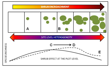
Australia’s semi-arid grazing lands have become severely degraded after more than 200 years of overgrazing by domestic herbivores. Overgrazing reduces plant and animal richness, alters soil, water and nutrient flows, and affects key ecosystem processes, resulting in landscape degradation. Landscape degradation is also associated with shrub encroachment, a global phenomenon characterised by an increase in the density of native woody plants (A to B).

Coalescing of single shrubs into patches (A to B) increases site-level heterogeneity. Increasing density (beyond B) may reduce the positive effects of shrubs through reduced resource movement and greater competition, reducing overall site-level heterogeneity. Grazing is thought to 1) move the maximum plot-level effect (C) to a point corresponding to greater shrub densities (D), because the co-occurrence of grazing and abiotic stress can maximize facilitation by shrubs, and 2) reduce biodiversity and soil function under the highest shrub densities (E).

Research by David Eldridge and Santiago Soliveres (Rey Juan Carlos University, Spain) seeks to reconcile two divergent views about shrublands and ecosystem processes by comparing the effects of grazing at patch (individual plant) and site (landscape) scales.
For more information contact David Eldridge (d.eldridge@unsw.edu.au, opens in a new window) aridecologylab.com.au, opens in a new window