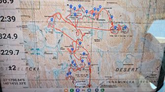
Date: Wednesday October 9th 2024
Project: Eastern Australian Waterbird Survey
Observers: Richard Kingsford (UNSW), Chris Sanderson
Pilot: Thomas Clark
We headed off early, north of Tibooburra to pick up survey Band 6 where we left off yesterday.
Tibooburra sunrise
A large local rainfall event earlier in the year had dumped water into a whole string of claypans, like this one, and small swamps. Over the last 41 years of the survey, these small wetlands are nearly always dry.
Inundated claypan near Tibooburra
Not today - they were full of large numbers of waterbirds at high densities relative to the small areas of wetland. They were very productive.
Inundated floodplains near Tibooburra
We then headed north west to the small South Australian town on Cooper Creek, Innamincka, to refuel.
Innamicka
We then headed northwest again to pick up Cooper Creek. This next survey involved additional wetlands, surveyed for the South Australian and Australian governments as part of the Lake Eyre Basin Agreement a survey of the waterbirds on Coongie Lakes. This is an internationally listed Ramsar wetland.
Cooper Creek
Surveying parts of Cooper Creek channels that connected Coongie Lakes
Part of this involved the drying floodplains of Coongie Lakes. We had originally planned to take around two and a half hours for this survey, but it took much longer.
Drying Coongie Lakes floodplains
Coongie Lakes is a magnificent wetland system. The numbers of waterbirds and the diversity were amazing. There were tens of thousands of Great Teal, Pink-eared Ducks and various fishing birds, including Pelicans and cormorants. There were also large numbers of ibis and Brolgas. And the largest flocks of Purple Swamphens I've ever seen. It was quite a sight to see.
Surveying one of the large Coongie Lakes
Coongie Lakes
There were also quite large swamp areas, drying back and connected to the large lakes with hundreds of waterbirds.
Meandering along one of the shallow channels connecting two of the large Coongie Lakes where there were hundreds of waterbirds feeding on the shallow water.
Here and there, we also surveyed parts of the Cooper Creek channel that connected to the lakes. These channels usually just have a few fish-eating birds like cormorants and egrets.
Cooper Creek channels
We then headed back across some more of the drying floodplains where the water was creating a complex pattern of connecting channels.
Coongie Lakes floodplain
The southern parts of the floodplain of Coongie Lakes were flooded, creating ‘fingers’ of floodlain trees with water flooded underneath.
The drying water created a maze of different channels crisscrossing with beautiful shades of brown up to maroon. The Coongie Lakes system is one of Australia’s great wetlands for biodiversity, reflected in the large diversity and number of waterbirds.
We headed south past Moomba Oil and Gas station to finish the survey day. Another long day but exciting and spectacular.
Moomba Oil and Gas Station

