Date: Sunday, October 8, 2017
Project: Eastern Australian Waterbird Survey
A 7.30 departure into cloudy weather had us heading southeast to our first wetland of the day in Band eight. A rain front is threatening from the west and causing us some anxiety. Will it stop us counting? What will the visibility be? Delaying the count by a day will cause major planning problems with accommodation. We keep our fingers crossed.
Despite all forecasts the rain never arrived but around the Biloela/ Emerald area good rain last week has left surface water and promoted a green pick for stock. Should another fall occur farmers and graziers will be ecstatic.
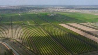
Emerald is where we refuel and it is clear from above it is a town in transition. The rich basalt soils support a healthy grain industry while the nearby dam boosts production of grapes and citrus. However, south of the town, sheltered from view by hills are the open cut coal mines which may be responsible for the many new houses in this central tableland town.
Photos: Terry Korn. Irrigation at Emerald, Queensland.
West of here there are few wetlands on our schedule and all are either dry or have no birds. This is the pattern all the way as we cross-crossed the Barcoo River before arriving at the famous Coopers Creek which at the same time last year was flooded.
Many farm dams are struggling to keep water up to stock
Photos : Terry Korn. The Barcoo River joins the Thomson River to form Coopers Creek.
