Date: Wednesday, November 1, 2017
Project: Eastern Australian Waterbird Survey
Up early, just on daybreak, and off today down the lower Murray to the Lower Lake and the Coorong, near Goolwa.
We started our survey on this part of the River Murray, just near where the Darling and Murray Rivers meet at Wentworth, at Lock 10.
From here we followed the River, all the way west and south to town of Berri. Most of the time, it was a case of surveying the different sections of river, conveniently broken up by the locks which hold the water artificially high so that the old paddle steamers and barges were able to navigate this river with their produce, such as wool, from upstream. Now the houseboats use them.
One of the locks on the River Murray which separate different sections of the river for us during our surveys.
We worked our way almost directly due west on this part of the river, which was stunning with the sun behind us and not much wind. There were a few waterbirds, sometimes up to 40 or 50 on the billabongs near the river, but not much action on the river from a waterbird point of view. The water was moving too fast and doesn’t allow waterbird food to build up.
Surveying the River Murray, west of Wentworth early in the morning.
We passed the odd houseboat on this part of the survey.
Not far west of Wentworth, the River Murray would have naturally diverted to fill up Lake Victoria which is now part of the major regulation of water in the whole system, allowing water management authorities to hold water in this lake for when needed downstream. As with all such lakes turned essentially into dams, they lose their value as waterbird habitat because they quickly lose their productivity as they no longer dry and fill naturally. We surveyed along Frenchmans Creek until the lake and then turned back to the river. This creek system has created quite a lot of wetland habitat and there were a few hundred waterbirds along here, as always.
Lake Victoria is used to store water for use downstream. This storage of water artificially has killed the trees that would have established with natural drying and filling patterns.
From here we headed west along the Chowilla-Lindsay-Walpolla system, an important target for environmental flows https://www.mdba.gov.au/managing-water/environmental-water/delivering-environmental-water/chowilla-floodplain-lindsay . We are increasingly seeing some impressive results for waterbirds in some of the northern lakes of this system, north of Renmark, which has come with the environmental flows. The flooding and drying of these lakes is very productive for waterbirds. There werent as many waterbirds here as last year but still a reasonably high diversity.
Pelican flocks took off under our plane while surveying one of the lakes on the Chowilla floodplain, north of Renmark.
From here we followed the curves of the river and its various associated lakes, all the way down to Banrock station before heading for the Lower Lakes and the Coorong. I had some anticipation that we would see huge numbers of waterbirds on the Lower Lakes and the Coorong, given how dry it was up north.
We surveyed the northern shoreline of Lake Alexandrina before reaching Goolwa for lunch. After lunch we then surveyed the rest of Lake Alexandrina and Lake Albert. These huge lakes take about a couple of hours to fly their perimeter.
Surveying the wetlands along the southeastern shoreline of Lake Alexandrina. These shallow water areas were great for waterbirds.
Surveying Lake Albert’s shallow water areas.
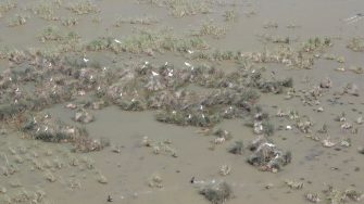
As with last year there was lots of breeding of spoonbills, cormorants and both species of ibis, straw-necked mostly but also Australian white ibis but the numbers weren't nearly as high as I had expected.
Small colony of royal spoonbills on Lake Alexandrina.
