Date: Monday, October 10, 2016
Project: Eastern Australian Waterbird Survey
Observer: Richard Kingsford
This is another of our long days, particularly because there is so much water around. We have to head west along Band 8 to the edge of the Simpson Desert, northwest of Birdsville and then southwest of Birdsville to start our eastern track along Band 7, which will eventually get us to Charleville this evening. Once again – a bit of dam ‘hopping’ as we surveyed a couple of dams.
Stock dams provide stopping off points for some of the waterbirds
We were in the air by 7am and heading west, crossing the north-south channels of the rivers and creeks. First Farrars Creek, Merabooka Creek and then once again the mighty Diamantina River. Most of the channels and waterholes have water, certainly a far cry from the usual. The creeks are bone dry when we come through at this time of the year usually.
The Diamantina floodplain stretched in all directions – water everywhere
In all my 30 odd years of flying this survey, I was not prepared for the sheets of floodwater flowing down the Diamantina. It was stunning watching this desert river in its full flood glory. There was no way we could even attempt to survey the whole area 30 km, the width of our survey band, and then about 5-10 km which was the width of the river. Instead we sampled a small portion of the floodplain. Once again, despite all the water, waterbirds were few and far between – a couple of black ducks and a flock of straw-necked ibis. There is so much habitat everywhere for these birds.
Surveying waterbirds across the vast Diamantina River floodplain
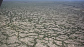
Next on our survey list of channel country rivers were King and Eyre Creek, near Bedourie, north of Birdsville. Eyre Creek had water everywhere, between the sand dunes. The very shallow water made up a patchwork of water and islands. And on many of these little islands, there were avocets nesting.
Once we had passed Eyre Creek, we surveyed, Lakes Phillipi, Torquinie and Mumbleberry. The latter two are right on the edge of the Simpson Desert, filling from the Mulligan River. Both had a fair way to go before they were filled and less than a couple of hundred waterbirds on each, even though they are very large lakes.
The ‘crazy-paving’ caused by the channels on Eyre Creek, spreading water across the floodplain
Lake Phillipi, a vast shallow water lake, with pairs of red-necked avocets and gull-billed terns breeding
Then – lunch (camel pies) in Birdsville, before heading south the Diamantina again and cutting across it on Band 7 which goes from here, in a straight line, all the way through to Maroochydore. There were lots of flood outs around the Diamantina but not as wet as I have previously seen it. Potentially the wave of water from the north will create more habitat.
Floodouts on the Diamantina River floodplain, south of Birdsville
A cockpit view of our survey team counting waterbirds on the Diamantina River, south of Birdsville
Soon we were passed the Diamantina and heading back east again. Here the Cooper can flow into the huge Lake Yamma but this was dry. Despite this, the Cooper was flowing across a large part of the floodplain. We spent a fair amount of time flying up and down the waterholes with their few pelicans.
Surveying the long waterholes of the Cooper Creek floodplain, just east of Lake Yamma Yamma
Many of the channels in the Cooper were flooded
With a 12 knot tail wind, we made good progress over the dry country to the east of the Lake Eyre Basin, which we soon left behind as we came over the ‘catchment hill’ to the Bulloo River Basin – another great channel country river. Before we reached Charleville, we crossed the upper reaches of two of the Murray-Darling’s most westerly rivers, the Paroo and Warrego Rivers. Charleville lies on the latter.
