Date: Monday, November 17, 2014
Project: Eastern Australian Waterbird Survey
Observer: Richard Kingsford
Our last survey day – more than a month since we started and after we have covered a lot of the eastern part of the continent. Our work today was to survey Lake Cowal on the Lachlan and then head south to pick up on a couple Riverina wetlands.
Lake Cowal is a majestic lake and a haven for waterbirds when it has water. The lake which had filled in 2010 was only about half full and very shallow. There were places in the middle which were drying.
Surveying Lake Cowal, one of the more important wetlands we have surveyed this year
Despite this, it was absolutely buzzing with waterbirds of every variety. There were thousands of pelicans, red-necked avocets, grey teal, pied stilts and even freckled duck. We were flat out counting into our tape recorders. It will be a bit of time until all our counts are added up but there must have been 20-30,000 waterbirds.
Photo 1. Thousands of pelicans and other waterbirds were spread right across Lake Cowal.
Unlike many large lakes that we survey, the waterbirds on Lake Cowal were spread across the lake. This is because it was so shallow that they could feed over the whole area. We started by surveying the edge of the lake and then did our surveys down the middle to complete the count of the lake.
Photo 2. Surveying around the edge of Lake Cowal
It was clear that the lake was not going to last much longer with the high temperatures driving evaporation. Already the carp were dying in their thousands and they were strewn around the edge and were floating in the middle. The shallow water has poor water quality, less oxygen, more salinity and sediment.
Photo 3. Dead carp around the edge of Lake Cowal
Once done, we headed for the Murrumbidgee wetlands. First on the list was Barrenbox Swamp. Water is held in storage here, after being used in the Murrumbidgee Irrigation Area. Its stark forest of dead trees is a testament to how the flooding regime for this wetland has been turned on its head. River red gums and black box trees that are permanently flooded in lakes soon die.
Photo 4. Dead floodplain trees cover Barrenbox Swamp, waterlogged
There were reasonable numbers of a variety of waterbird species, dominated by the fish-eating birds such as pelicans and cormorants. Flocks of thirty to fifty grey teal rose up in front of the plane in the shallows.
Surveying Barrenbox Swamp in the Riverina
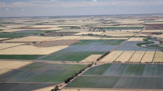
This is a landscape that is dominated by irrigated crops, particularly rice, where the rivers and creeks snake through the straight edge farmed areas on either side.
Photo 5. Irrigated crops on either side of Mirrool Creek which flows into Barrenbox Swamp
Our final destination was Hume Dam. On the way we flew over the newly gazetted Nature Reserve of Doodle Comer Swamp, near Henty. Undoubtedly a great wetland when it had water but today it was dry.
Hume Dam covers a massive area – it took us nearly an hour to fly its perimeter twice. We do two counts on many wetlands to get some estimate of counting error.
It stores 3,000,000ML (about six Sydney Harbour’s worth) of water on the River Murray which can then be released downstream for irrigation. But it is deep and for all of its large area, it has relatively few waterbirds. Today it was 67% full.
Photo 6. Hume Dam with few shallow water areas for waterbirds to feed
Hume Dam on the River Murray is mostly deep water which suits some of the fish eating waterbirds which feed on the fish but compared to natural wetlands of this size, there is not the numbers or diversity of waterbirds that you would find on similar sized natural wetland on a river. Most of the waterbirds we found were clustered up in the shallow areas in the north and south arm of the dam.
Surveying along the barren shorelines of Hume Dam
And on that, we finished the waterbird survey of 2014 – the 32nd year.
