Our research

Explore our latest innovative research.

Personalise
TRACSLab, rCITI researcj

rCITI’s Research areas

The rCITI team pursues high quality interdisciplinary transport research and development through investigation of sustainable approaches to transport infrastructure and operations. We highly value research impact and extensively liaise with industry and government.

Integrated Infrastructure Strategic Planning

rCITI develops new techniques and mathematical engineering tools that permit the enhancement of infrastructure construction, maintenance, management and rehabilitation.

We reshape the nature of integrated transport policy, planning, optimisation, financing, delivery and real-time management for more robust, informed and ethical infrastructure.

We undertake world-class research for a wide range of clients and collaborators in the following areas:

  • Transportation network modelling
  • Large-scale integrated transport optimisation and planning

For more information please contact:

 rciti@unsw.edu.au

Human-Centred and Automated Systems Design

Our research is to design a transport system (drivers, vehicles, the environment and their interactions) that takes into account human capabilities, limitations and other characteristics in order to optimise system performance and make it safe, easy, efficient and satisfying to use.

We undertake world-class research for a wide range of clients and collaborators in the following areas:

  • Road user behaviour, performance, and safety
  • Driver education and training
  • Human interaction with automated, intelligent, and connected vehicles
  • Road, traffic and smart infrastructure design and evaluation
  • Sociotechnical system analysis and safety

For more information please contact:

rciti@unsw.edu.au  

Engineering Smart Cities & Logistics

We conceive, develop and deploy efficient and scalable approaches to engineering problems in smart cities infrastructure design and optimise of logistical systems.

We undertake world-class research for a wide range of clients and collaborators in the following areas:

  • Logistics
  • Supply chain and freight transportation
  • Agent-based modelling
  • Mobility and Logistics as a Service
  • Automated vehicles
  • Blockchain technology

For more information please contact:

rciti@unsw.edu.au

Deep Data, Digitisation & Decisions

Our research looks at emerging data sources, modelling methods and technologies. rCITI is a leading group in theorising, initiating, developing and inventing new techniques, tools and methods. Our researchers apply artificial intelligence, machine learning and statistical approaches to take advantage of new concepts such as shared mobility, and non-traditional data sources such as big crowdsourced data.


We undertake world-class research for a wide range of clients and collaborators in the following areas:

  • Crowd sourced data utilisation
  • Travel demand modelling
  • Land use modelling
  • Activity-based modelling
  • Transport econometrics

For more information please contact:

rciti@unsw.edu.au

Connected Mobility Services

We research the ease and flexibility of getting people and goods from one point to another, and the integration of different transport modes. Connected mobility is fundamental to the success of our cities. We develop strategies to efficiently and effectively deploy, operate and manage emerging mobility services, taking advantage of enhanced technologies for automation, connectivity, digitalisation, and electrification. These strategies help to accommodate challenges from traffic congestion, vehicular emission, aging infrastructure and rapid urbanisation.

This team undertakes world-class research for a wide range of clients in the following areas:

  • Agent-based freight transport modelling
  • Blockchain, Logistics 4.0 and digital supply chain
  • Smart heavy vehicles tracking and monitoring
  • Automated, electric and hydrogen heavy vehicles

For more information please contact:

rciti@unsw.edu.au

Research highlights

The Research Centre for Integrated Transport Innovation (rCITI) has continued to expand and strengthen its network across campus and with relevant government and industry.

Lead CI: Prof. Vinayak Dixit

Manager: Mr. Julius Secadiningrat

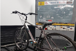
Established from our ARC Linkage Infrastructure Equipment and Facility (LIEF) 2013 grant, the TRAvel Choice Simulation LABoratory, (TRACSLab) is a world-first in multi-modal, multi-user transportation visualisation platform. The facility allows researchers to study travel choice and interdependent behavioural characteristics by observation of group interactions.

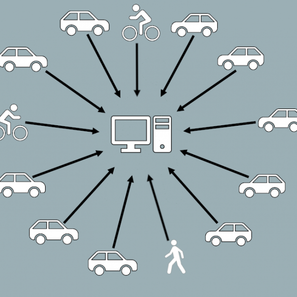
TRACSLab @ UNSW is made up of transport simulators (i.e. driving, cycling, and pedestrian simulators) networked together to answer fundamental research questions relating to travel choice, drivers’ behaviour and human factors, risk and safety, automotive technology, and infrastructure design.  

Transport Simulators for Safe, Flexible, and Consistent Testing Environment Generating Accurate Results

TRACSLab @ UNSW offers academic researchers, industry collaborators, and policy makers a safe and cost-effective platform to conduct experiment and test bedding of new technology or policy which otherwise would be too impractical or costly to be tested in real world. The facility is built on a custom simulator platform developed in-house by rCITI researchers and it is highly customisable and immersive. The open-source nature of the platform means that new functions can be programmed and added to suit each project requirements.

A high-fidelity environment can be 3D-modelled according to real world conditions, including traffic signage, building models, road furniture (bus stop, road lights, barriers, etc), and road markings, and placed anywhere inside the simulation environment. Experiment parameters (e.g., weather, traffic composition and volume, time of day, etc.) can be set to consistently replicate a particular scenario. TRACSLab has also the ability to integrate with standard traffic microsimulation software, which is widely adopted in traffic studies and policy-making process, to accurately simulates traffic behaviour. Complete observability and rich data collection are supported by state-of-the-art data collection instruments such as high-frequency data loggers, physiological monitoring devices, and eye trackers.

See our facilities page for more details.

Learn more

Initial Scoping and Feasibility (Project Number: 3-027)

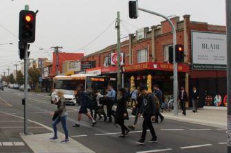
Desire lines are the most direct and shortest walking route between modes of transport but not necessarily the safest and designated route. Where the provided route is longer and deviates from this desire line then a proportion of users will not use it, electing instead to take the shortest route.

The purpose of this project is to study the route choice behaviour of pedestrians and their attitudes towards desire lines around public transport interchanges. The outcomes of which will assist infrastructure designers to provide better outcomes for users with respect to pedestrian routes at interchanges.

This work will complement the Department of Transport Victoria’s Strategy and its Road Safety Strategy and is aimed to improve the pedestrian and vulnerable road users’ experience when using the public transport systems.

Project objectives:

The goal of this project is to deliver a people-focused connectivity to the public transport system that enhances a simple, safe, and connected journey for vulnerable and unprotected road users.

The objectives of this project are twofold:

  1. Identify the behavioural and socio-demographic factors affecting the choice of desire lines versus the designated pedestrian routes at the public transport stations and level crossing interchanges.
  2. Identify the pedestrian connector routes design requirements based on the in-field behavioural evidence and the literature review.

The outcomes will assist infrastructure designers in providing better outcomes for users with respect to pedestrian routes at interchanges. This project will complement the Vic DoT Strategy and Vic Road Safety Strategy and is aimed at improving the pedestrian and vulnerable road users' experience when using the public transport systems.

Project Activities:

A field survey will be undertaken on 21-27 November 2022 at these two public transport stops in Melbourne:

  • Queensbridge at Crown.
  • Russell Street/Bourke Street intersection.

Please see the survey participation Information Statement.

For more information please contact:

Elli Irannezhad  E: e.irannezhad@unsw.edu.au 
PH: 0432 712 822


A Case Study of New South Wales, Australia

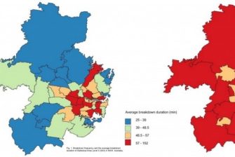
Traffic incidents such as crashes, vehicle breakdowns, and hazards impact traffic speeds and induce congestion. Recognising the factors that influence the frequency of these traffic incidents is helpful in proposing countermeasures. There have been several studies evaluating crash frequencies. However, research on other incident types is sparse. Here, we identify critical variables that affect the frequency and duration of reported vehicle breakdowns in New South Wales, Australia.

The results indicate that increases in population density, the number of registered vehicles, the number of public holidays, average temperature, the percentage of heavy vehicles, and the percentage of white-collared jobs in an area increase the number of breakdowns. On the other hand, an increase in the percentage of unrestricted driving licenses and families with children, the number of school holidays, and average rainfall decrease the breakdown frequency.
With regards to breakdown duration, road network connectivity, hierarchy, and familiarity factors have mixed (both positive and negative) impact on duration; higher road network density, mixed land-use, and spatial disorientation of roads are associated with longer duration; and higher income and exposure (vehicle kilometres travelled) are associated with shorter duration.

Papers:

  • Chand, S., Moylan, E., Waller, S. T., & Dixit, V. (2020). Analysis of vehicle breakdown frequency: A case study of New South Wales, Australia. Sustainability (Switzerland)12(19). doi:10.3390/su12198244
  • Chand, S., Li, Z., Dixit, V. V., & Travis Waller, S. (2021). Examining the macro-level factors affecting vehicle breakdown duration. International Journal of Transportation Science and Technology. doi:10.1016/j.ijtst.2021.03.003

For more information please contact:
Dr Sai Chand
E: saichand.chakka@unsw.edu.au

Driving Simulator Research Studies in Tunnel Environment

Road tunnels are major pieces of infrastructure across the road network, and the number of tunnels in Australia is expected to increase in the coming years. An examination of recorded road crashes found that, although they are relatively safe when compared with other parts of the road network, there are still a significant number of crashes that have occurred within tunnels. Therefore, it is important to explore new methods and technologies to improve the safety of road tunnels.

At rCITI, our human factor and simulation experts are working with Austroads to evaluate a number of safety treatments and aesthetic design features in NSW tunnels, particularly their impact on safety, driving performance, and user experience. The studies are enabled by TRACSLab @ UNSW virtual reality driving simulator platform which can provide an accurate and immersive representation of the tunnel environment with an all-encompassing (360 degrees horizontal and vertical) view. Using this set-up, experiment participants are able to experience the feeling of driving while being encompassed by the tunnel environment with new safety treatments and aesthetic design features. Furthermore, rCITI human factor team also develop several subjective questionnaires, which captures user’s perceptions and feelings of the tunnel treatments, to complement driving data collected by the simulator platform.

The studies demonstrate the capability of rCITI’s simulator facilities in providing a safe and cost-effective test-bedding platform to conduct evaluation of transportation technology and policy which otherwise would be too impractical or costly to be tested in real world. The findings from the studies can potentially result in revealing important knowledge regarding the impact of tunnel treatments and design features on safety, driving performance, and user experience, which will be beneficial to inform policy makers and infrastructure operators while also improving safety for users.

For more information please contact:

Professor Vinayak Dixit
E: v.dixit@unsw.edu.au

Emeritus Professor Michael Regan
E: m.regan@unsw.edu.au

Julius Secadiningrat
E: j.secadiningrat@unsw.edu.au

rCITI Partnering with Cardno for Safety After Dark Innovation Challenge

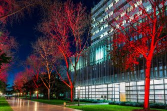
The UNSW School of Civil and Environmental Engineering has partnered with Cardno to deliver a game changer project for Transport for NSW to empower women to make informed choices about their travel. The project outcomes are also expected to inform Transport for NSW on targeted ways that could improve safety after dark for women.

Transport for NSW is trialling innovative data and technology ideas to improve safety for women travelling at night in Greater Sydney as part of the Safety After Dark Innovation Challenge. The innovative idea presented and currently being developed by UNSW-Cardno team examines the key factors in safety after dark for women as being passive surveillance and the comfort it can bring. The team is quantifying passive surveillance in a web and/or mobile application that can be used by women to make informed choices on their travel. A passive surveillance index for each street would be determined through a multi-criteria assessment of the closing times of street level establishments (restaurants, shops, services, etc.) and other contributing factors.

Passive surveillance is essential in a transit environment after dark, because it reduces opportunities for crimes against women to occur, and at the same time improves personal safety perception. Providing knowledge of areas with higher passive surveillance invites women to more freely participate in the community at night. The project aims to produce for Transport for NSW an action plan that can be used to implement design, technology and behavioural changes to improve safety.

For more information please contact:
UNSW lead – Dr Meead Saberi
E: meead.saberi@unsw.edu.au

Bike infrastructure

This collaboration with TfNSW under the iMOVE CRC develops virtual reality systems to evaluate bicycle infrastructure. The study investigates how to integrate cycling facilities into urban and suburban environments in ways that address the concerns of the 48% of people who are interested in cycling but concerned about safety.

A highly innovative element will be the use of immersive virtual reality technology and behavioural observations, rather than only stated preference approaches. Thus, providing an improved evidence base that will be utilised through the next iteration of cycleway design guidelines.

For more information please contact:

Professor Vinayak Dixit
E:  v.dixit@unsw.edu.au

Macroscopic parking dynamics modelling and optimal real-time pricing considering cruising-for-parking

We quantify and assess the effect of cruising-for-parking by developing a neighbourhood-scale macroscopic parking dynamics model. Given limited parking supply, cruising-for-parking is explicitly modelled as well as the flow interactions between on- and off-street parking operations. The model is built upon system dynamics of different families of vehicles using macroscopic traffic flow theory. Each family of vehicles features a unique driving state. For example, all the vehicles currently cruising for parking belong to the same family with the state being “cruising”.

To reduce parking congestion and improve the network performance, two real-time parking pricing strategies are developed and compared where the price is of a pay-per-entry type. The first strategy is a feedback or reactive pricing scheme driven by the parking occupancy. Assuming that parking occupancy data are available in real-time through installed road-side units such as cameras or sensors, we could utilize such data and apply trial-and-error which is the core of the feedback scheme. The second strategy is a model-based predictive or proactive pricing scheme that explicitly minimises the expected aggregate cruising delays. At the beginning of each time interval, an optimisation problem is solved for a finite time horizon to obtain the optimal price for this interval.

Assessment of Bluetooth and Wi-Fi data for transport operations and planning purposes, as part of the Network Performance and Anomaly Detection Project

The purpose of this project is to explore potential use cases for data generated from Bluetooth and Wi-Fi Sensors. The data generated from each of these sensors provide a location of sensor, time stamp, a unique one-way hashed device id, potentially type of device and the corresponding signal strength.

The data will be analysed from three main perspectives:

  1. Explore potential risks, e.g. around privacy and identify potential mitigation strategies.
  2. Use cases with respect to data.
  3. Accuracy and the operational robustness of data with respect to associated benchmarks.

For more information please contact:

Professor Vinayak Dixit
E:  v.dixit@unsw.edu.au

E-network for rail-based cane transport systems

Sugar Research Australia (SRA), in collaboration with Advisian, UNSW and MoTh, is looking to facilitate the improvement of efficiency and safety (thereby reducing cost) of the cane transport system by establishing real-time monitoring of infrastructure and mobile assets. The project explores options to develop and implement such operations and processes.

For more information please contact:

Professor Vinayak Dixit
E: v.dixit@unsw.edu.au

Professor S. Travis Waller
E: s.waller@unsw.edu.au

TfNSW - Level of Service

Researcher(s): Prof. S. Travis Waller, Dr. Kasun Wijayaratna, Dr Sisi Jian, Dr Divya Nair

The future of Level of Service – Accounting for Movement and Place: Development of the NSW Road Planning Framework

Level of Service (LoS) is a traffic engineering grading system used to assess the performance of transport infrastructure, such as road corridors and intersections. The LoS methodology offers practitioners a tool to identify failing infrastructure and accordingly develop remediating actions to improve the service provided to a customer.

LoS assessments of roads have generally focused on the movement of vehicles. However, roads serve not only for the purposes of ‘movement’ of private vehicles but also as a ‘place’ which supports activities conducted on adjacent land uses. Depending on the context, the community desires road segments that are free of congestion for vehicles, are safe to walk and cycle on and provide accessibility to commercial and employment opportunities. Transport for New South Wales (TfNSW) are at the forefront of capturing the duality of road corridors through the newly formed ‘Movement and Place’ (M&P) concept which has developed LoS metrics that focus on place as well as movement along a road corridor.

RCITI is collaborating with TfNSW to benchmark the M&P concept to enhance the NSW Road Planning Framework. This research has developed an aggregation methodology to define singular holistic LoS metrics that account for multiple modes of transport as well as the movement functionality and the place environment of a road corridor.

GoGet Carshare – safer and more fuel efficient driving

rCITI researchers: Dr Vinayak Dixit, Prof S. Travis Waller, A/Prof Taha Hossein Rashidi, Dr Lauren Gardner Dr Zhitao Xiong and Mr Bruce Jeffrey's

Imagine being able to use technology to influence driver behaviour to be safer and more fuel efficient?

At rCITI, we have partnered with GoGet to develop an Integrated Intelligent Vehicular System (IIVS) that is on its way to doing just that.

By setting up one of GoGet’s fleet vehicle with an on-board computer, front and side radar detectors and a forward facing intelligent camera, software collects and analyses traffic data to evaluate crash risk propensity and fuel efficiency of driving.

This project is at the forefront of using technology to influence human behaviour and promote safer and more fuel efficient behaviour through incentive mechanisms, and is expected to influence transportation and insurance policies. Most importantly, this project will contribute towards a broader framework for Intelligent Transport Systems.

For more information please contact:

Professor Vinayak Dixit
E:  v.dixit@unsw.edu.au

In pursuit of the world’s best ramp metering strategies

rCITI research team: Prof. S. Travis Waller, Dr Vinayak Dixit, Dr Hanna Grzybowska, Nima Amini, Kasun Wijayaratna, William Manning

Ramp meters are a cost-effective method used for relieving traffic congestion by controlling the frequency vehicles enter the traffic flowing onto a motorway. They have been shown to not only significantly reduce travel time but also increase driver safety. But what are the best performing ramp metering systems being used around the world and why?

The TfNSW Department of Roads and Maritime Services has engaged rCITI to conduct a study into ramp metering strategies used around the world consisting of a detailed literature review and including an understanding of the algorithms that underpin these strategies.

As part of the analysis, rCITI are categorising the Ramp Metering methods of control and algorithms, and reporting the highlights and functional descriptions of each algorithm. The interesting thing is that while the functionalities of the algorithms remain valid through time, the physical developments of the Ramp Metering strategies are continually being updated.

The review takes into consideration specific case studies of the implementation and evaluation of specific algorithms with the United States of America, Europe and Australia/Asia.

In addition to a literature review, rCITI are interviewing key organisations and individuals involved in the deployment and operation of these Ramp Metering strategies within Australia and New Zealand.

For more information please contact:

Professor S. Travis Waller
E:  s.waller@unsw.edu.au

The recovery and distribution of surplus food – making it work!

rCITI researcher team: Dr Vinayak DixitDr Taha Hossein Rashidi & Divya Jayakumar Nair

Thousands of tons of fresh food is thrown into landfill each year by the food industry, but not-for profit organisations like Foodbank and OzHarvest have come to the rescue, literally. They ‘rescuing’ this food and transport it to places and people who could benefit from it.

The concept is, however, more complex than it might seem – with real-life decision-making processes, handling risk and uncertainties considered critical in food rescue operations.

Collaboration aimed at driving efficiency

rCITI researchers have collaborated with Foodbank and OzHarvest to enhance the planning and management system by developing a decision support system for the real time recovery and distribution of surplus food – taking into consideration the uncertainties in recovery and fairness in distribution.

The core research conducted in the domains of demand modelling, clustering and dynamic vehicle routing algorithm development, simulation and optimisation.

Three primary areas of involvement

The specific activities for rCITI within this project consist of three primary aims:-

  • To understand the mobility needs of the vulnerable population and develop strategies so as to utilise these services for broader mobility outreach.
  • To conduct research and develop tools.
  • To implement learnings and introduce tools in situ.

Each activity is collaborative work between rCITI, Foodbank (Sydney) and OzHarvest (Sydney).

The total duration of the project is three years and includes three specific applications including a recovery prediction model, a distribution model accounting for equity and fairness, and a dynamic clustering and routing model which incorporates the uncertainty in recovery.

For more information please contact:

Professor Vinayak Dixit
E:  v.dixit@unsw.edu.au

Modelling Disease Spread through Global Transport Systems

rCITI Researcher: Dr Lauren Gardner

Modern transport systems bridge previously isolated geographic regions around the globe. Throughout history infected travelers have been responsible for introducing infectious diseases into new regions, with copious examples in the past decade (e.g., SARS, MERS-CoV, H1N1).

Additionally, climate change and transport have jointly resulted in vector-borne diseases such as dengue, malaria, and chikungunya becoming established in regions which were previously unsuitable habitats. The introduction of a new disease into a region challenges the local healthcare system and results in significant economic costs. Furthermore, improved network connectivity and rising traffic volumes continue to increase the risk of disease spread posed by the global transport system.

To address these challenges this research exploits the use of network optimization tools to predict and analyze the impact transport systems play in the regional and global dispersal of disease. This work represents a novel integration of multi-model transport systems, epidemiological processes and environmental data, to model both contact-based and vector-borne disease risk.

The contributions of this work include:

i) The use of real-time spatiotemporal infection data (case reports) to predict spreading patterns for ongoing outbreaks.
ii) Identifying data that would be the most valuable to collect for modeling purposes and incentivise specific data collection efforts.
iii) Quantifying disease importation risk through specific air travel routes, airports, sea ports, etc, and iv) aiding public health policy in the design of surveillance and intervention strategies.

Specific diseases that have been previously addressed in this line of research include: 

  • 2009 Swine Flu
  • MERS-CoV
  • H5N1 and H7N9 Avian Influenzas
  • Dengue Fever

rCITI Researcher: Dr Lauren Gardner

L M Gardner, S Sarkar, Transportation Research Record: Journal of the Transportation Research Board, No. 2501, Transportation Research Board, Washington D.C., 2015, pp. 25-30. DOI: 10.3141/2501-04
Enhancing the NSW Transport System

rCITI Research Team: Prof. S. Travis Waller, Dr Vinayak Dixit, Dr David Rey, Dr Hanna Grzybowska, Dr Melissa Duell, Dr Emily Moylan, Dr Zhitao Xiong, Nima Amini, Sai Chand Chakka, Milad Ghasrikhouzani, Tuo Mao, and Neeraj Saxena.

For a research centre completely dedicated to transport infrastructure research, it makes sense that a close bond would be formed with the government organisation in charge of the state’s transport network. That’s exactly what has occurred with a recent collaboration with Transport for NSW (TfNSW) that aims to enhance the planning and management of the NSW integrated transport system.

Through the partnership, rCITI will develop and incorporate world-leading methodologies on intermodal regional dynamic network analysis, closely interact with and train agency staff, employ university students in hands-on project activities, and create the next generation of analysis techniques to benefit the NSW's transport system and subsequently all of the travelling public.

The project was conducted over a 3 year period with four specific applications, each of which relies on specific research, training and project implementation activities.

  • Application 1 - corridor travel time prediction
  • Application 2 - regional dynamic transport network modelling for planning
  • Application 3 - sub-network travel time prediction (follows Application 1)
  • Application 4 - robust network-wide prediction modelling which incorporates daily volatility (follows Application 2)

For more information please contact:

Professor S. Travis Waller
E:  s.waller@unsw.edu.au

Learn more

More flexible models for measuring Travel Demand

rCITI Researcher: Dr Taha Hossein Rashidi

Modelling the demand for transport is a vital component of urban design and planning. But being able to model travel demand effectively and accurately is no easy task. There are multiple variables to consider, each which can have an effect on the others.

Ultimately the demand for transport comes about because of the activity happening at the end of the trip. The way modelling has conventionally occurred is through measuring the physical trips of people into transport analysis zones. This allows planners to develop mathematical models to forecast travel attributes based on all trips generated from and attracted to a zone.

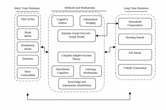
As a major alternative to this traditional approach considers the activities and decision makers through another paradigm called “activity-based modelling” (based on discrete choice modelling). Over time, the mathematical complexity of the discrete choice models has grown rapidly resulting in equation-based models which are computationally intensive and do not necessarily reflect the behaviour of the decision maker. Thus, numerous simplifying assumptions are made to make these systems of models operational.

This research at  rCITI explores several less computationally intensive methods that better reflect the behaviour of decision makers and can take into account the complexities resulted by interactions between agents. Basic concepts of learning-based methods and random graph models have only been employed in activity-based models in a limited manner while their usefulness has not been sufficiently examined. 

Further, this research explores the practicality of complex adaptive system theory in travel demand modelling, as applications of this theory in fields other than transport are growing.

Major decisions modelled in an activity-based model along with methods that will be used to model them.

Driving Simulator Research Studies in Tunnel Environment

On demand mobility services such as ride-sharing and ride-sourcing represent a great challenge for urban communities in that it often comes in the form of a new transport mode associated with an uncertain reaction of the network users. rCITI has partnered with Keolis Downer to develop new solutions for on demand public transport.

This collaborative initiative resulted in multiple projects involving notably the design of dynamic bus routing and scheduling algorithms to explore the potential of on demand public transport within the metropolitan region of Newcastle, NSW, Australia; and the development of surveys to estimate the demand for on demand mobility services across the Northern Beaches and Macquarie Park as part of the TfNSW on demand transport trials. rCITI has also conceived performance evaluation frameworks to measure the impact of on demand transport and assist local transport authorities in deploying innovative on demand mobility solutions.