- UNSW
- ...
- Water Research Laboratory
- Our research
- Clybucca Wetlands management options study
- Home
- About us
-
Our research
- Australian coastal observation network
- Big Swamp restoration project
- Cars in floods: Vehicle stability testing for flood flows
- Caseys Beach seawall upgrade
- Climate change in NSW estuaries
- Clybucca monitoring
- Clybucca Wetlands management options study
- Coastal adaptation needs for extreme events and climate change, Avarua, Rarotonga, Cook Islands
- CoastSat
- CoastSnap
- Cold water pollution: A review
- Eurobodalla Shire Council coastal hazard assessment
- Hunter River water quality model
- Hunter scoping study
- Kingscliff seawall design
- Manly coastal hazard assessment
- NSW coastal floodplain prioritisation project
- Oceanlinx wave energy system physical modelling
- Oyster reef restoration project
- Physical modelling of Bounty Bay breakwater, Pitcairn Island
- Port Fairy coastal hazard assessment
- Scrivener Dam physical model
- The mystery of Thirlmere Lakes
- Tomago Wetland monitoring
- Tomago Wetland restoration project
- Tube fishway project
- Tuckean Swamp drainage options study
- Yeramba Lagoon restoration
- Facilities & equipment
- Our expertise
- News
- Contact us

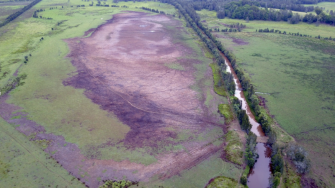
The low-lying areas of Mayes Swamp and Doughboy Swamp on the Collombatti-Clybucca floodplain were historically natural backswamp wetlands. Significant drainage infrastructure constructed over the 20th century has promoted rapid drainage and lower surface and groundwater levels. This has resulted in exposure of acid sulfate soils that discharge acidic waters (pH ~ 3). Prolonged inundation after floods can also lead to ‘blackwater’ runoff which has very low dissolved oxygen. These processes degrade the wetland areas and impact downstream aquatic ecosystems in the wider Macleay River Estuary.
In recent years, the Department of Transport for NSW (previously NSW Roads and Maritime Services (RMS)) purchased a large area of low-lying land on the Collombatti-Clybucca floodplain for biodiversity offsets as part of the Pacific Highway upgrade project. This land includes the Mayes Swamp and Doughboy Swamp areas. These areas have been identified for rehabilitation to improve the wetland habitats of the floodplain and improve water quality.
Three years of data collection and analysis und...
In recent years, the Department of Transport for NSW (previously NSW Roads and Maritime Services (RMS)) purchased a large area of low-lying land on the Collombatti-Clybucca floodplain for biodiversity offsets as part of the Pacific Highway upgrade project. This land includes the Mayes Swamp and Doughboy Swamp areas. These areas have been identified for rehabilitation to improve the wetland habitats of the floodplain and improve water quality.
Three years of data collection and analysis undertaken by the Water Research Laboratory has identified several rehabilitation options for the Clybucca Wetlands (approximately 3,500 hectares) using detailed hydrodynamic modelling tools to predict how drainage management will influence wetland depth and extent. This research was funded by the Saltwater Recreational Fishing Trust’s Flagship Fish Habitat Action Plan and sets the scene for on-ground works to improve the health of this important wetland system.
The success of this project can be attributed to the collaborative approach of the project stakeholders, including; Local Land Services, Kempsey Shire Council, National Parks and Wildlife Services, Department of Planning, Industry and Environment (formerly OEH), Department of Primary Industry – Fisheries, RMS, NSW EPA, and Crown Lands. Further, community feedback and discussions were an integral contribution to the outcomes of this study. Local landholders, the Seven Oaks Drainage Union, local community groups, and relevant government agencies, were consulted on their views of working towards a sustainable management solution for the study area.


