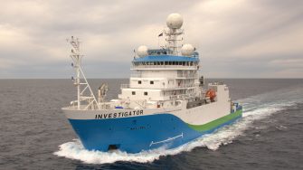
Chasing satellites and storms: all aboard the 101st voyage of the RV Investigator
Researchers from UNSW will lead a 24-day mission to improve ocean forecasting and the sustainable management of Australia’s ocean sector.
Researchers from UNSW will lead a 24-day mission to improve ocean forecasting and the sustainable management of Australia’s ocean sector.

A team of over 40 scientists from UNSW Sydney, opens in a new window, the University of Tasmania, opens in a new window, Bureau of Meteorology, opens in a new window and CSIRO, opens in a new window will embark on the 101st voyage of the CSIRO research vessel, RV Investigator.
Departing from Sydney on October 9, the oceanographers, atmospheric scientists and CSIRO technical team will chase ocean eddies and storms, collect physical and bio-geochemical samples and track a newly launched $1.5B NASA/CNES satellite, opens in a new window.
The essential data gathered during their time at sea will grow our understanding of ocean circulation and productivity, leading to improved ocean forecasting and climate modelling.
"This voyage has been three years in the making. Amongst us we have RV Investigator-veterans returning to sea and many up-and-coming higher degree research students who have never been at sea before. We’re all very excited to begin this mission", says Professor Moninya Roughan, Chief Scientist of the voyage.
Orbiting 891km above the Earth is the NASA/CNES Surface Water and Ocean Topography (SWOT) satellite, opens in a new window, equipped to measure changes in the elevation of the surface of the ocean with 10 times the resolving power of previous instruments.
The SWOT satellite’s increased resolving power – the equivalent to jumping from black and white television to HDTV – will reveal ocean currents that are crucial for climate resilience, marine heatwaves, maritime safety, and food security. This will be one of the first Australian efforts, and one of the first internationally to use the SWOT pathfinder data.
“SWOT will dramatically enhance our view of the ocean, resolving upper ocean currents at an unprecedented scale. Our team will be one of the first to use SWOT data to better understand ocean dynamics in Australia's marine environment. It comes at an interesting time, with Australia having just entered an El Niño event caused by the interaction of ocean winds and currents,” says Associate Professor Shane Keating, who leads of the Australian SWOT working group and will be one of the oceanographers onboard RV Investigator.
Before we can use SWOT data, they must first be validated by taking observations in the ocean.
Circling off the coast of southeastern Australia are many ocean eddies, circular vortices of water that are the oceanic equivalent of storms and weather systems in the atmosphere.
The boundary where two eddies meet is a complex and dynamic cauldron for physical, chemical and bio-geochemical processes. These boundaries transport nutrients and phytoplankton – the energy source for marine foodwebs – and the exchange of gases between air and sea.
Information collected as part of the voyage will validate the data from the SWOT mission and assist in the development of accurate models of eddy driven currents to predict their size, shape, formation and evolution.
Eddies hold vast amounts of heat. Understanding how they transport and retain this heat is important for understanding climate change and ocean warming. This information will improve ocean forecasting, particularly in relation to marine heat waves and climate change, and improve the sustainable management of Australian marine industries and the seafood sector.
The voyage will expand on previous internationally acclaimed research studying the currents on the east coast of Australia, to gain a close-up understanding of eddy dynamics and their effect on air-sea gas exchange, productivity and atmospheric weather pattens.
The voyage team (including 9 PhD students) will deploy an array of scientific instruments, opens in a new window equipped to capture in real-time the movement of currents at the surface (with satellite-tracked floating buoys or drifters). They will also profile through the water column to measure important indicators such as heat, salinity and productivity (using ‘CTDs’).
Recording this vital information will enable greater predictions of how ocean warming will impact currents and subsequent transfer of warmer water, opens in a new window, productivity and exchange of gases.
Understanding and predicting weather patterns has become increasingly important, particularly as Australia just entered an El Niño weather event, opens in a new window – this means that drier weather combined with climate change could lead to a fierce bushfire season. But the impacts on our regional seas are less clear. This voyage will give insight into El Niño impacts on ocean dynamics along southeastern Australia.
Data collected from this voyage will also enhance the predictive capacity of weather forecasts, including those from the Bureau of Meteorology, and assist with climate risk assessment and prediction.
“For many people, these currents are out of sight, out of mind but they won’t stay that way. We must gather data now on these dynamic currents, and how they move heat around, to better predict their movement in the future,” says Prof. Moninya Roughan. “As these vital currents change, they will impact the lives and livelihoods of millions of people who live along the east coast of Australia and we need to be forewarned”.
This research is supported by a grant of sea time on RV Investigator from the CSIRO Marine National Facility which is supported by the Australian Government’s National Collaborative Research Infrastructure Strategy (NCRIS).
The voyage also has participants from the University of Technology Sydney, opens in a new window, University of the Sunshine Coast, opens in a new window, University of Melbourne, opens in a new window, and University of Auckland, opens in a new window New Zealand.